 ranch (512)
264-1449
ranch (512)
264-1449
fax (512) 264-1449
About the Area
Lake Travis is a flood control lake and the water level fluctuates as water is taken out for irrigation and public water systems. In times of heavy rain and floods, the water level can rise dramatically in a very brief period of time.
Property Description
The Lazy J Ranch's 257 acre parcel is irregularly shaped. The eastern property boundary is Lake Travis. Two ephemeral creeks run from west to east through the property and drain into Lake Travis. The high point of the property, 890 ft MSL, can be found along the western border while the low paint of 700 ft MSL is located along Lake Travis. The general slope of the property is from west to east. The northern part of the property is more steeply sloped than the southern part.
Habitats
- Southern part of the property is largely a live oak parkland with persimmon, agarita, cedar elm, tree tobacco, and regrowth juniper. Herbaceous plants include King Ranch bluestem, silver bluestem, little bluestem, green sprangletop, and Mexican hat.
- The southern part of the property also includes a riparian area where the dominant trees are cedar elm, life oak and juniper. The herbaceous plants are dominated by Lindheimer muhly and little bluestem.
- The northern property is primarily a juniper/oak woodland where the canopy cover is over 80%. The trees are dominated by juniper and live oak although several Spanish oak are present. Herbaceous plants in this shallow soil habitat include cedar sedge under the canopies while little bluestem, hairy grama, seep muhly and dominanita are present along the woodland edges.
Soil Types
- BID Brackett-rock outcrop complex 1-12% slopes
- PuC Purves soils, undulating
- VoD Volente sitty clay loam 1-8% slopes
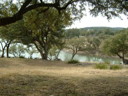
Main cove on Lake Travis